By the way, I misspelled the name of the town where Hoppies is located. It is Kimmswick, MO for those playing the home game. Google it. It is a really cute town. This is Fern Hopkins, the queen of Hoppies Marine. She knows more about the Mississippi and the rivers down to Mobile than anyone. She gave us a thorough review of the current knowledge including where to anchor and how to deal with tows on the Mississippi. We could never have had the confidence to deal with this portion of the trip without Fern and her team. Everything she said was absolutely true.

I am not sure I gave you a true flavor for this "marina". It is a marina in that it has good people to help you out, fuel, restrooms, and a safe place to tie up. It is different from other marinas in that it is right on the Mississippi with tows passing all day and all night. It is built on barges that are hooked together so it is strong and floats with the river. You can see the way the boats are tied to the barge in this photo which also reveals how low the Mississippi is right now based on the amount of bank that is dry.

 They also host commercial fishermen like these fellows I saw the morning we left. These are the guys who caught so much catfish the week before that their boat almost went under. Or maybe that was just another tall tale from this land of Mark Twain!
So we left Kimmswick MO very early on Sunday September 30 to begin the 277 mile journey without gas. We have six five gallon tanks on the back deck.
I am reading Mark Twain's, Life on the Mississippi. He says the Mississippi boils like grease in a frying pan. Sure enough, it still looks that way! I wonder if you can see the little whirls in this photo? It is hard to capture. It is not like a wake or waves but little pools of disturbance that make the boat move in funny ways if you don't hold on tight while steering.

The Mississippi is bland with trees on the edges and miles and miles of dirt on the banks. Very little activity can be seen on the land. No people and no other boats other than our little band and the tows that come regularly.


This is a neat little island created by the river. You can see the layers of mud.

It is also very cold while we are traveling. The entire river trip since leaving Hoppies was in the 40s and 50s, even colder in the evening. We were bundled up tight with sweaters, coats, jeans, and socks. I even wrapped myself in a blanket I got so chilled. See the little nest we create?


Rusty slept most of this trip. Occasionally he gets up to change to a different spot or flip on to the other side. He is very used to traveling now. Such a good doggy!!

On Sunday night we anchored at Mile 102, tying 5 boats in a row. Rusty had his first dinghy ride to go potty. We both took him. He ran and rolled like crazy - actually like a dog freed from prison. We are still getting the sand out of him. I don't think a bath will help!
The first day we traveled 56 miles and used 45.6 gallons of gas.
On Monday we traveled as far as we could on the Mississippi, anchoring at Mile 2, Angelos Towhead, at the mouth of the Ohio River at Cairo IL. For you non-Illinoisians, it is pronounced KA ro, with a long A, not like the capital of Egypt. People around here talk with a southern accent, making it difficult to understand the tow captains when they respond on the radio. they make a transmission and we all look at each other and say, "what did he say?", we process it and respond as best we can.
We traveled 101.5 miles the second day and used 78 gallons of gas. So far total traveled was 157 miles using 123.6 gallons of gas. Remember the tank holds 300 and we have 30 gallons in plastic cans on our back deck. We have used about half the gas and we are more than half way through this journey. Pretty good! Although we were feeling confident, we put 15 gallons in the port gas tank. We would have put the other 15 in the starboard tank but we were tied to Sareanna for the night on the starboard side and did not want to put gas in our tanks close to their windows.


The anchorage was behind a little spit of sand. We could see it went into a little river but we could also see stumps that indicated we ought not go beyond. So we anchored in two groups. We were further in the channel tied to Sareanna and the other three boats were tied together a little closer to the channel but still safe. This pictures shows Kermit taking Rusty to the land to use the potty, driving passed the other three boats in our group. The land was mostly mud so Kermit and the dog got very dirty. You should see the little dinghy. It is the perfect vessel for our purposes though. So stable that even the dog feels comfortable. Well sort of comfortable.
The third morning, Tuesday morning, we were supposed to depart at 7am, our usual time. That means we have to get up at 5:30am, stretch a little, dress, feed the dog, get the dog out for his ride to use the facilities, eat breakfast, and untie the boat. We set the coffee alarm because it is nice to wake up to the smell of coffee. On Tuesday morning we woke to a loud KNOCK KNOCK. Evidently the coffee alarm failed us and Dick from Sareanna knocked on the boat because he did not see any lights. Thank goodness he did! It was 6:30am so we jumped into action and accelerated the entire process. Dog into the dinghy, off to the land, did his business, we hopped the dinghy into it's loaded position and we were off exactly at 7am. WOW WHAT A MORNING!!
We left Angelos Towpath and entered the Ohio River. We could see the town of Cairo on the left side (port side, or Right Descending Bank) on the Ohio River. The Ohio River runs into the Mississippi so instead of having a 3 mph advantage from the Mississippi current, we have a 1 or 2 mph disadvantage running upstream on the Ohio. This is a big deal considering our mileage and gas concerns. On the Mississippi we were doing about 12mph thanks to the current. On the Ohio we were doing about 7mph all the while doing the same 2000 rpm. So with the same energy coming out of the engines we made less progress.
The Mississippi is measured in miles. When we say we were at Mile 0, that is the end of the Upper Mississippi which is measured from Minneapolis to Cairo. At Cairo, the Mississippi begins the Lower Mississippi, measured from Cairo to New Orleans. We did not take the Lower Miss. We switched into the Ohio where the numbers start at 981 and go to 0 where the Ohio begins.
The Ohio River looks like it has more water than the Miss. But is looks and feels the same. Tows, water, barges, and trees on the edge. A few fishermen now and again so we saw a few ramps. No marinas and little interaction with people anywhere on the river.
There are two locks we passed through on the Ohio, Lock 53 and Lock 52. Very creative names. A new lock is being built next to Lock 53 that will be called the Olmstead Lock. Lock 53 is a wicket lock. Not sure exactly what a wicket looks like but evidently in high water, which this is right now on the Ohio, the wickets or pickets are lowered so boats can go over the dam instead of through the lock. So we sailed right across the dam. It was a funny feeling and we were quite concerned. We had 16 feet of water under us so there was no trouble. I learned later that the problem is not the depth but the current. You have to have quite a head of steam to get passed the downriver current while you are moving upriver. Some boats can't do it and have to go back and try again with a bigger head of steam. In fact, the catamaran, Catmandu, that we joined up with on the third day had this problem.
It is hard to see but this is the new dam being built at Lock 53. We crossed the dam just next to the long wall on the right.

We traveled to Mile 923 on the Ohio from Mile 981, anchoring at the Cumberland Towhead at the mouth of the Cumberland River. We traveled a total of 58 miles using 75 gallons of fuel. On the second day we traveled 102 miles using 78 gallons of gas. Mmmmm.... I guess there is an advantage to the Mississippi current after all!! So since we left Hoppies have travelled 215 miles using 198 gallons of fuel. We have a 300 gallon tank so we have about 100 gallons left plus the 15 gallons left in plastic cans. We have about 65 miles to Green Turtle Bay Marina in Lake Barkley, our next gas opportunity. I think we can make it.
We anchored at the Cumberland Towhead picking up a sixth boat, Catmandu the catamaran that doesn't go very fast. He made a joke. We passed some turtles on the Cumberland River. We were going about 8mph, a little slower than our usual but in the range we usually run. We saw the turtles and said hello. Catmandu traveling at 2mph not only saw the turtles but met their sisters, brothers, and cousins, had dinner with them and heard them complain about the wake we made when we passed!! Notice the clever use of a mail box post to hold his radar? And with that many diesel cans, he rarely needs to stop for fuel, although even with good diesel mileage when you go 2mph it can take forever to make the trip we make each day.

A word about docktails while anchoring. It is a blast!! We usually met on One September because their Viking Sportfish has a a fabulous salon that fits everyone comfortably. Everyone brings something and we munch and drink and laugh and tell tall tales. It is a wonderful way to travel. It is sort of like chit chatting on the dock.
Back to the journey. The Cumberland River is very beautiful. We were the lead boat. Boy did we draw lucky duty. No traffic, not one tow. Just beautiful shoreline and perfect water.


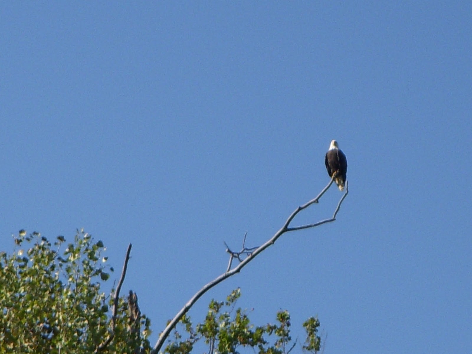
Critter alert: This is bald eagle territory. We got an amazing series of pictures of this eagle sitting in a tree then taking off to soar. He obligingly went back to show himself to our fellow travelers.


There are two choices when leaving the Ohio River. Take the Tennessee River route into Kentucky Lake for 69.5 miles with 3 locks to our final destination, Green Turtle Bay. Or you can take the Cumberland River route into Lake Barkley for 89.9 miles with one lock. We chose the Cumberland River route because there are such long delays reported at the Kentucky Lake Lock. We didn't want to take the chance of wasting fuel at delays with a lock.
Having left at our usual 7am on Wednesday morning, we arrived at the big Barkley Dam and Lock about 10am only to find that the lock was shut down for maintenance and we would have to wait until 4pm to get through!! All that and we had to wait anyway.


This is a really big lock, going up 53 feet but it was smooth as silk. The lock master called us in at about 2:30pm. The secret to locks is being nice to the lock master, doing what you are told when you are told to do it. If you make their life easier they will make your life easier.


The new microwave arrived and mechanics will be crawling around the generator (again) and fixing the railings. Kermit and I will be cleaning, restocking the provisions, going to the gym, and relaxing. Rusty requested a very long walk. More about Green Turtle Bay later.
We traveled 65 miles on fourth day for a total of 277 miles. We filled up at Green Turtle Bay Marina putting 100 gallons in each side exactly. That means we used about 230 gallons to travel 277 miles, arriving at the end with about 1/4 tank of gas. Just about perfect planning, despite ourselves.
What we learned about this journey:
o Traveling with a group makes everything better, especially the group we lucked out with. They are wonderful people. Everyone has good seamanship skills and is very helpful.
o Anchoring is fun. We were so tired anyway we wanted to go to bed at 8 or 9pm. Total cost of lodging during the last 3 nights: $0. Entertainment value: priceless.
o Anything dirty can be made clean again. Pitch in and enjoy the mess.
o Proper planning trumps all fears. We couldn't have been more prepared. After this we can do anything!!
Comments from friends about previous posts included more details on the generator problems we are having. We don't think we overloaded it. We always started the generator with every utility that would be served by the generator in the off position. We don't think it is operator error or installation error. Now we think there might be something wrong with a switch or something fundamental with the generator itself. Kermit will report more details in the next post.
Larry, my switch to the new phone went perfectly because I backed up using Backup Assistant and Google Sync. The new Droid 4 is just fine! And we will use this break in Green Turtle Bay to get those photos on Flikr so everyone can see what they want. I have most things labeled with location and description so it is a matter of getting it done.
Thanks to everyone for the comments and support. We miss you all but we are having a completely wonderful time. And we are getting along really well which should shock many people who know us!! Welcome to Aunt Rochelle who is now getting our blog through the staff at her retirement home. I love you Aunt Ro!! Happy Birthday!!
No comments:
Post a Comment